

A farm manager opens the telematics dashboard on a Tuesday morning. Three months of data: engine hours, fuel consumption events, fault codes, field-operation logs from four machines. The data is there. It has been there since September. Nobody has queried it since it arrived.
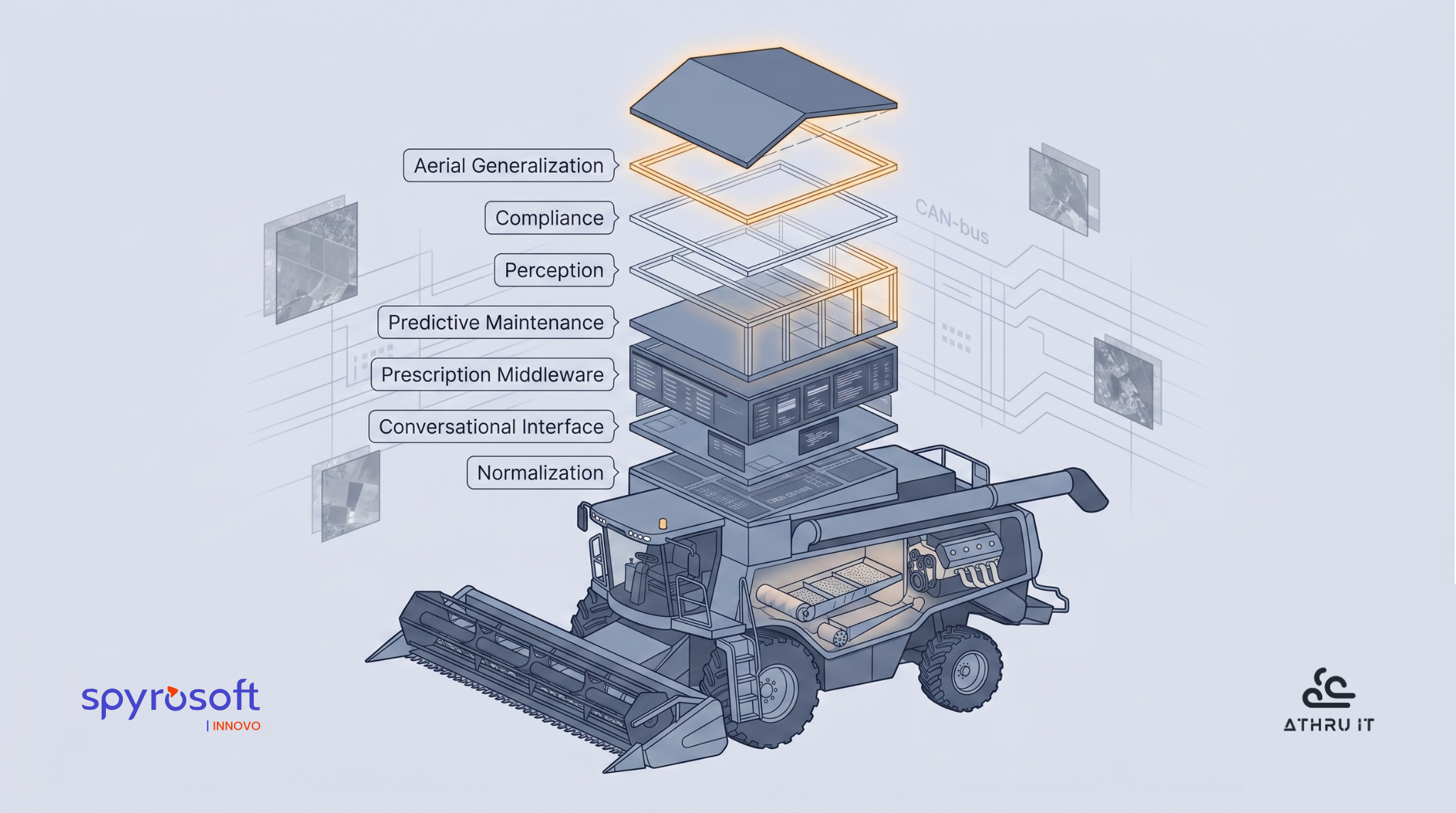
Agricultural machinery digitalization and AI are not about the autonomous tractor. That is the headline. The actual story is the CAN-bus data streams accumulating on dashboards that nobody queries - and the seven software layers that sit between connected machines and operational outcomes, each underbuilt, each requiring a different AI capability.
The machines are connected. Modern combines report. Sprayers log what they applied and where. Tractors broadcast engine performance and hydraulic pressure in real time. The hardware problem is largely solved. What does not exist, across most operations, is the software layer that converts that data into a decision.
Seven gaps define that space:
- The normalization pipeline that makes multi-brand data readable in one place.
- The natural-language interface that lets an operator ask a plain question and get an actionable answer.
- The prescription middleware that turns yield maps and telemetry into variable-rate prescriptions.
- The failure-prediction model that converts a sensor anomaly into a parts order before the breakdown.
- The perception module that makes autonomous operation safe in dust and crop occlusion.
- The documentation pipeline that produces compliance reports directly from machine logs.
- The aerial analytics model that generalizes across geographies instead of overfitting to the region where it was trained.
None of these is the autonomous tractor. All of them are real problems with credible AI solution profiles. Each one sits in a different part of the stack. None of them has been built as general infrastructure.
That is what this article covers.
1. The Foundation Layer: Precision Agriculture Data Interoperability Across Mixed Fleets
Every real farm operation runs equipment from multiple manufacturers. A combine from one brand, a tractor from another, a sprayer from a third - each with its own telematics system, its own data format, its own cloud platform. Getting a unified view of what those machines are doing at the same time is not a configuration problem. It is a standards problem that the industry has been working on for decades and has not yet solved.
ISOBUS (ISO 11783) is the established in-cab communication standard. The Agricultural Industry Electronics Foundation develops conformance tests and maintains a database that lets users assess compatibility between brands. Those tests exist because plug-and-play functionality across brands is what growers expect but not what the standard guarantees. Conformance testing manages the expectation; it does not close the integration gap between a tractor from one manufacturer and an implement from another.
At the data exchange layer, ISOXML covers logged task and field data exchanged between farm management information systems and machines - an established building block for data exchange. But ISOXML addresses recorded operation data, not live telemetry streams from proprietary OEM cloud platforms. Those streams run through separate APIs, and connecting two of them requires a bilateral agreement with its own legal terms and maintenance overhead.
The ADAPT Standard 1.0, released by AgGateway in June 2024, is a significant step toward precision agriculture data interoperability. Built on JSON Schema, GeoParquet, and controlled vocabularies, it ensures that both producer and consumer share a clear understanding of data meaning and units across field operations data. The standard has accumulated over 500,000 downloads since 2014. It works alongside ISOXML rather than replacing it, and it addresses farm data normalization for logged data exchange but leaves the live telemetry gap open.
AgIN - the AEF's Agricultural Interoperability Network - addresses that gap at the cloud level. Instead of bilateral integrations, each requiring separate legal agreements and maintenance overhead, AgIN offers a single AEF membership and common connector software, available February 2025. Data types covered include machine data, work orders, and work records. Participants include AGCO, John Deere, CNH Industrial, CLAAS, Kubota, and over 30 other organizations. Production release is targeted for September 2026 - a target, not a guarantee; ISOBUS itself took decades to reach widespread adoption, and mixed-fleet telematics normalization at this cloud scale has no precedent in agriculture.
Interoperability is not solved. But whoever builds the layer that makes multi-brand fleet data readable in one place controls the unified data view - and that view is the customer relationship. This is not a feature. It is the infrastructure everything else in this article sits on.
A unified data view solves the format problem. The interface problem - how an operator actually queries it - is the next layer.
2. Conversational Interfaces: Turning Farm Telematics Data into AI-Driven Decisions
The telematics dashboard shows everything and answers nothing. Engine performance, hydraulic pressure, temperatures, fault codes, fuel consumption, field-operation logs - the data accumulates. The gap is not data volume. The gap is the interface: no operator should have to know which table in which database to query in order to understand why combine 3 underperformed on Tuesday.
LLM-based copilots grounded in fleet, yield, and agronomic data can change that. The ADMA Copilot, a proof-of-concept multi-agent system published in 2024, demonstrates that an LLM controller can "understand user's intent, make plans for data processing pipelines and accomplish tasks automatically" against agricultural datasets. The system uses a meta-program graph to decouple control flow from data flow - which reduces the hallucination risk that comes from asking a general-purpose LLM to produce a precise fuel consumption figure or yield variance. Agricultural data requires high-confidence outputs. The architecture addresses that constraint.
The scope is substantial. Agricultural data management currently spans collection, curation, integration, loading, storing, sharing, and analysis - tasks that "still involve too much human effort" at every stage. A natural-language interface running against normalized farm telematics data can compress several of those stages into a single query and return an answer in operational context, rather than requiring the operator to assemble it from separate dashboards.
The operationally important distinction is between a chatbot and an agent. A chatbot answers "why did combine 3 underperform Tuesday?" and returns text. An agent closes the loop: scheduling a service check, flagging a prescription deviation, routing an alert to the dealer. The text answer is a starting point. The action is the point. This distinction is what the agentic architecture enables, not merely describes.
Two constraints apply. LLMs require domain-specific grounding to avoid hallucination on precision claims - ADMA Copilot addresses this through decoupled data flow but remains early-stage as of 2024. Any natural-language interface also requires normalized fleet data to work against. An LLM copilot running against five separate OEM data formats is a demonstration, not a product. The query layer depends on the foundation layer.
Getting an actionable answer is one gap. Turning it into a variable-rate prescription that a machine can execute is the next.
3. The Decision Gap: Agronomic Middleware Between Machine Data and Prescriptions
Yield maps accumulate. CAN-bus streams flow. At the end of the season, the data is there and the variable-rate prescription is not. This is the middleware gap: the decision layer between what the machine logged and what the agronomist needs to recommend has not been built as general infrastructure. The gap is not a data problem. It is an integration and reasoning problem.
The data problem was solved first. Sensors collect. Satellites image. Machines broadcast application and engine data in real time. The question that remains unanswered in most operations is which service converts all of that - telemetry streams, historical yield patterns, soil data, live weather inputs - into a variable-rate prescription that a machine can execute the next morning. That service, running continuously on all the data a farm generates, does not exist as a common, open-architecture layer.
Research on information fusion in smart agriculture confirms that integrating IoT sensor data, satellite imagery, and weather inputs into unified decision-support architectures is an active area of investigation. The approaches described represent the target state for this decision layer: multi-source data flowing into field models that output actionable recommendations. The gap between what the research describes as prototype directions and what practitioners need as operational infrastructure is substantial.
Part of the gap is organizational. Encoding the agronomic expertise required to convert yield-map anomalies into variable-rate prescriptions requires sustained collaboration between ML engineers and agronomists - a combination that is organizationally difficult to sustain across teams. Several farm management information systems address parts of this stack within their own ecosystems. The cross-platform, open-architecture version remains unbuilt.
Variable-rate application machinery can follow a prescription map. That is not the problem. The problem is automatic generation of that map from raw telemetry. Yield maps and CAN-bus data do not spontaneously become prescriptions. A service has to interpret them, and that service requires agronomic reasoning embedded in software - not just data access.
A combine failure at peak harvest is one consequence of the machine data layer and the decision layer remaining disconnected. That failure mode belongs to the next section.
4. Agricultural Predictive Maintenance: From CAN-Bus Streams to Failure Forecasts
A combine harvesting 100 acres per day breaks down for two days during the harvest window. Two hundred acres sit unharvested. Rain moves in. Grain moisture rises, dockage costs at the elevator increase, and the timing gap between optimal and late harvest translates to $27–$45 per acre in lost revenue. Moving corn from 27% moisture to 15% adds approximately 40 cents per bushel in fuel alone. Unplanned breakdowns cost U.S. farmers an estimated $3,348 per season. The seasonal math on a combine failure is not additive. It is compounding.
What makes this worse is that most of the data required to prevent it is already being broadcast.
Modern agricultural equipment manufactured post-2015 ships with factory telematics. CAN-bus data streams covering engine performance, hydraulic pressure, temperatures, fault codes, and fuel consumption are already flowing from the machine to a platform. Farm equipment repair costs rose over 40% since 2020. The primary analytical gap is not sensor coverage. It is the layer above the sensors: the model that converts multi-channel telemetry streams into a failure forecast before the failure happens.
That gap is specific. Multiple sensor types measuring different components over different time windows overwhelm standard monitoring tools. A cooling sensor reading that looks normal in isolation can indicate a fault when correlated with fuel injection timing - a cross-system pattern that conventional monitoring missed in a documented engine failure case. The individual reading was within tolerance. The pattern across systems was not.
Structural fault detection and diagnosis for combine harvesters is an established research domain with peer-reviewed literature as of mid-2025. The academic foundation exists. What is less uniformly deployed is the production layer: agricultural predictive maintenance telematics running continuously on live data, connected to dealer-side triage and parts inventory. The value of a failure forecast doubles when it generates a service window and a parts order rather than just an alert.
Smaller fleets face a cold-start problem - failure-prediction models require failure history to train on. OEM-locked telematics constrains the multi-brand datasets needed to build cross-platform models, which circles back to the normalization gap in the foundation layer. Published accuracy figures from trade press lack confirmed independent sources in the available literature and should not be treated as validated benchmarks.
The highest-value deployment is fleet-wide, cross-brand, and connected end-to-end to parts logistics. That combination is not yet standard.
Failure prediction covers what breaks inside the machine. Detecting what is in its path while it operates is the next gap.
5. Computer Vision for Agricultural Autonomy: The Perception Safety Layer
Agricultural autonomy is not primarily a hardware problem. The hardware - guidance systems, machine vision platforms, obstacle detection sensors - exists and is deployed. The problem is perception: person and obstacle detection that achieves production-quality accuracy under agricultural field conditions. Those conditions are not what autonomous vehicle datasets were built for.
Direct sun angles cause detection failures that controlled environments do not surface. Dust reduces sensor reliability. Crops occlude obstacles and people. Ground surfaces break the planar assumptions baked into models trained on roads. People in agricultural environments crouch, lie down, and move through crop rows in poses that urban person-detection models have no training data for. These are not edge cases. They are the field.
The FieldSAFE dataset, published in 2017, established the foundational multi-sensor benchmark for agricultural obstacle detection because no public dataset addressed multi-modal obstacle detection in agricultural environments before it. A camera, thermal imager, LiDAR, and radar mounted on a tractor in a grass mowing scenario. What it documented was the failure of urban-trained models in unstructured agricultural terrain - a failure not fully resolved at production scale.
A 2024 paper introducing YOLOv8-PSS achieved 90.6% mean average precision with a 55.8% parameter reduction versus base YOLOv8, making it viable for on-edge deployment without connectivity. Failure modes in the same study include detection failures in inadequate lighting or backlighting conditions, reduced accuracy when obstacles are occluded by trees or crops, and a single front-facing camera that cannot cover the full detection field when tractors shift between forward and reverse gear.
Zero-shot panoramic detection approaches are in active research as a direction that could reduce the per-field retraining requirement. Full methodology and validated performance metrics for those approaches are not in the open literature.
The right build is plug-in perception modules that extend existing autonomy stacks, not replacement platforms. Multi-sensor fusion - LiDAR combined with thermal, radar, and camera systems - improves reliability in adverse conditions at a proportional cost in per-OEM integration work. The agricultural machinery AI software layer for autonomy safety is more open than the headline narrative suggests, and it is being built from the sensor edge inward.
Perception governs what the machine detects during an operation. What it must record and report from that operation is a different layer.
6. Compliance Documentation as Agricultural Machinery Data Output
The CAP 2023–2027 ties direct payments to nine Good Agricultural and Environmental Conditions (GAEC) covering soil management, crop rotation, wetland protection, and related farming practices. Compliance requires verifiable evidence: what field activity occurred, when, with what inputs, across which GPS coordinates. That is the same information agricultural machinery already logs by default.
The connection between what the machine logs and what the compliance report requires has not been automated at scale. The machine generates the record; the farmer generates the compliance report separately. A targeted review regulation entered into force in 2024 specifically to reduce farmer administrative burden. The infrastructure to automate this connection exists. The pipeline to convert machine logs into audit-ready compliance documentation at scale has not been built as a general-purpose layer.
Per the project description, the Tools4CAP EU Horizon project focuses specifically on integrating farm-level data sources - including machinery-generated data - into CAP monitoring and evaluation processes. Its existence as a recognized EU research priority confirms that the gap between machine data and compliance documentation is structural, not a record-keeping problem that better spreadsheets would fix.
The business argument for closing it is retention. A farmer whose GAEC documentation pipeline runs automatically from machine logs does not churn from the platform generating those reports. The switching cost is re-documentation: returning to manual processes during a season when compliance deadlines do not pause.
GAEC standards change. National implementing rules differ across EU member states. A compliance automation pipeline built tightly to current GAEC definitions carries real risk of partial obsolescence with each revision cycle. Carbon credit frameworks are not part of the CAP conditionality framework and are not uniform across markets.
Compliance documentation automation is unglamorous. That is the point. Unglamorous and sticky is the retention argument.
Ground-level documentation covers what the machine did. The seventh gap is the view from above.
7. Drone and Satellite Generalization: The Cross-Crop Analytics Frontier
The unresolved problem in drone and satellite field analytics is not image resolution. Multi-spectral NDVI mapping is commercially available. UAV platforms are widely deployed. The frontier is generalization: most existing ML models were trained on a specific crop type in a specific geography, and their accuracy degrades when applied beyond those conditions.
A 2025 Frontiers in Agronomy review documents this directly: deep learning models experience performance degradation of 12–18% when transferred across diverse agroecological zones. NDVI correlations reach R-squared 0.71 and EVI2 correlations R-squared 0.77 for within-region applications - figures that assume regional consistency and break down at global scale.
The operational architecture that addresses this combines UAV high-resolution multispectral imaging at 0.1–5 centimeters per pixel with satellite broad-area coverage at 10–30 meters per pixel, enabling centimeter-scale nutrient management while maintaining hectare-scale operational perspective. The combination works for high-value, localized interventions. Cross-crop satellite remote sensing that generalizes reliably across diverse regions is the unsolved layer.
Cross-region transfer learning with limited labeled data is the research direction addressing that gap. Kerner et al. (2024) demonstrate multi-region transfer learning for crop field boundary segmentation in satellite imagery, showing that models trained with limited local labels can transfer across diverse agricultural regions. Production systems serving diverse geographies continue to require region-specific retraining in most deployments.
Regulatory variation adds a constraint that generalization research alone cannot resolve. Drone regulations vary across jurisdictions and include restrictions on airspace authorization, beyond-visual-line-of-sight permissions, and pesticide application constraints. A drone analytics platform built for one national regulatory context requires substantive re-engineering before it operates in another.
The defensible build is multi-spectral, multi-source, and designed for cross-crop generalization from the outset - not adapted after the accuracy floor is hit in a new geography.
That is the seventh and final gap. The conclusion traces what all seven reveal together.
Seven Gaps, One Diagnosis
Seven gaps described. Seven different AI problems. None of them is the autonomous tractor.
The normalization layer. The conversational interface. The prescription middleware. The predictive maintenance analytics. The perception safety module. The compliance documentation pipeline. The cross-region aerial generalization model. These are not seven separate product categories. They are seven floors of the same building, and none of them is finished.
A farm technology director who can name all seven has a sharper diagnosis of their digital estate than any agri machinery digital services platform pitch offers. The value is not in the list. The value is in understanding that these gaps are structurally connected. The conversational interface requires normalized data to query. The prescription middleware requires the conversational layer to surface its outputs. The predictive maintenance system requires cross-brand telemetry to train on. The order matters. The dependencies are real.
Agricultural machinery digitalization and AI are making these gaps impossible to ignore - not because the technology is newly capable, but because the distance between what connected machines now generate and what operations can do with it has become too wide to miss.
The industry has been selling the roof before the foundation is finished. The foundation is seven layers deep.